You or someone using this computer or device previously created Trip Plans.
What should we do with these plans?
Make these Trip Plans part of my account
Discard these Trip Plans
Login
Some text here
Password Reset
Please enter the email you used to set up your account.
We'll send a link to use to reset your password.
Check Your Email
If there is an account with the email address , we will send you a link to reset your password
Natural Bridges
Natural Bridges National Monument is located about 45 minutes from Blanding, Utah. The monument is best known for its three natural bridges, Kachina, Owachomo, and the largest, Sipapu, which is also the second largest natural bridge in the world. The bridge names come from the Hopi tribe, which once dominated the region. Sipapu, for example, is the Hopi word for the gateway which souls pass through to the spirit world, and Kachina is named for traditional Hopi spirit dancers. Owachomo Bridge is defined by a rock formation at one end, and aptly named with the Hopi word for 'rock mound.'
Natural Bridges National Monument is located on a tree-covered mesa surrounded by white canyons. A great way to explore the monument is by driving the nine-mile scenic loop which leads to overlooks for all three bridges. A short walking trail at each scenic stop leads to the viewing points.
To get the most from any visit to Natural Bridges National Monument, moderate trails (all under 1.5 miles roundtrip) lead to the base of each bridge. Owachomo Trail is the shortest, about a half-mile roundtrip with some rocky steps. The trail to Sipapu Bridge is steep and rocky but there are stairs and wooden ladders to aid hikers. There is a ledge about halfway down the trail that offers an excellent view of Sipapu. Kachina is the “youngest” bridge with a relatively small opening compared to Sipapu and Owachomo. In 1992, about 4,000 tons of rock fell from Kachina, as evidenced by a huge pile of boulders near the bridge’s base.
Other trails in Natural Bridges National Monument are the Loop Trail, which passes all three bridges, and Horsecollar Ruin Overlook Trail, a fairly level trail that crosses the mesa to the edge of White Canyon. The overlook features a view of an ancestral Puebloan cliff dwelling.
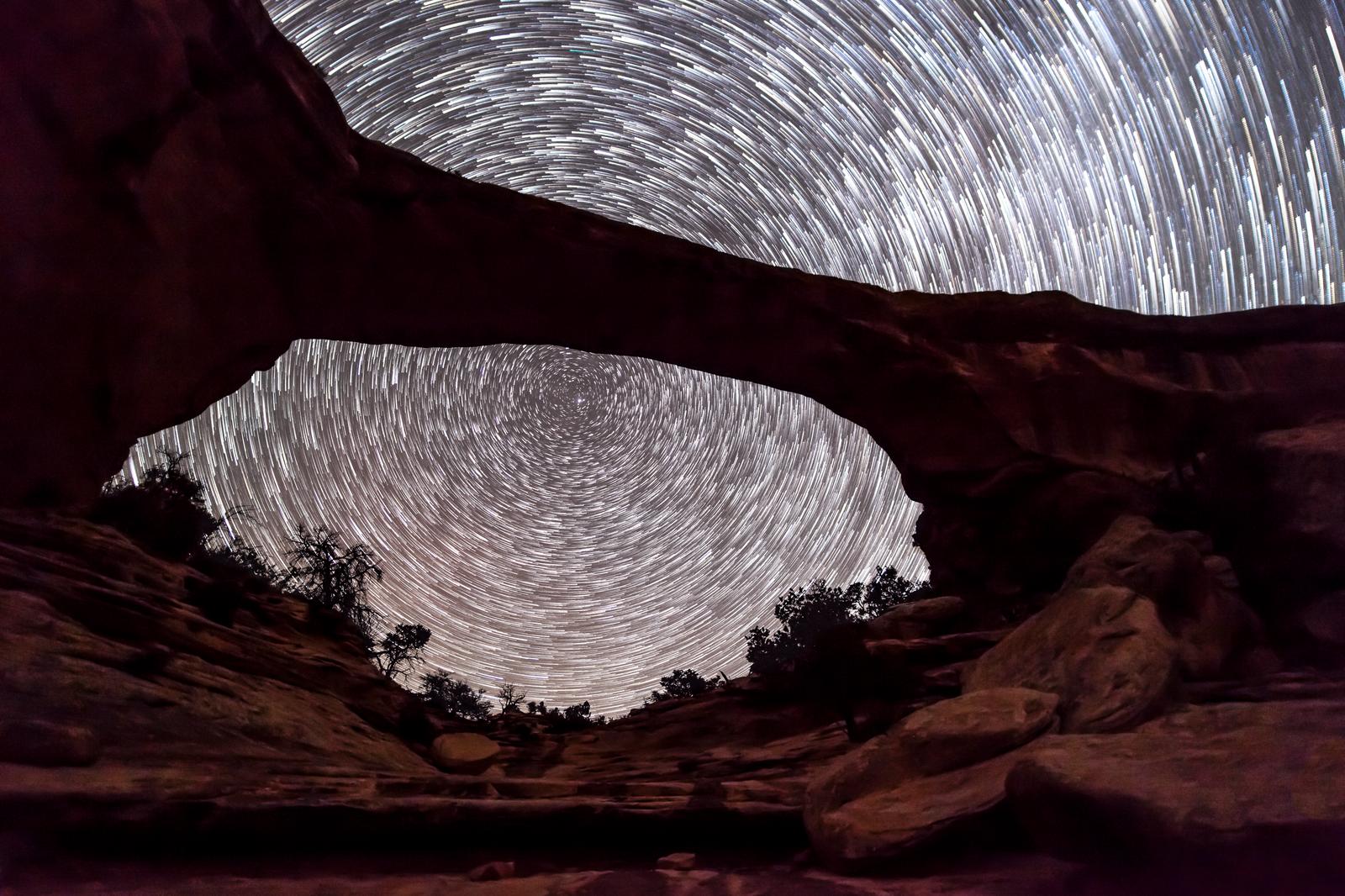
Dark Sky Program
Home to some of the darkest skies in the country, in 2007 Natural Bridges became the world's first 'International Dark Sky Park' certified by the International Dark Sky Association. Natural Bridges has made protecting its dark sky a priority so that in some areas, it's possible to see up to 15,000 stars throughout the night. In contrast, fewer than 500 stars may be visible from more urban environments.
Astronomy programs are held at dusk in front of the visitor center Wednesday & Thursday nights, May-October. Visitors are encouraged to bring a chair or blanket to sit on. Please contact the park before your visit to verify times and dates.
A natural bridge is formed primarily by water erosion. Water shapes the streambeds at the base of the canyons, eventually eroding enough of the canyon walls so that it flows beneath it to create a natural bridge. Evidence shows that at least two more natural bridges once existed here. The bridges in Natural Bridges National Monument are carved from Cedar Mesa white sandstone, remnants of ancient sand dunes from the Permian period, around 250 million years ago. Nearby White Canyon also gets its name from the white Cedar Mesa sandstone.
Natural Bridges National Monument’s elevation ranges from 5,500 feet to 6,500 feet. Flora throughout much of the park is typical of the high-desert vegetation found throughout much of southern Utah, although willow and cottonwood trees flourish near the streams along the canyon floor. Off-road vehicles are heavily restricted within the monument boundaries, allowing much of the native vegetation and cryptobiotic soils to thrive.
Natural Bridges National Monument services include a visitor center with ranger-guided walks and interpretive programs. A 13-site campground is available on a first-come basis. The monument is open daily year-round. The visitor center is closed on Thanksgiving, Christmas, and New Year’s Day.
Mexican Hat, Bluff, Blanding, and Monticello offer convenient access to the monument, as well as gas, food, and lodging. Head north on Highway 261 to Highway 95 from Mexican Hat. Head north on US Highway 191 from Bluff, or head south on US Highway 191 to reach the monument from Monticello or Blanding. Stay on Highway 95 for about 30 miles and turn right onto Highway 275. The entrance to Natural Bridges National Monument is at the end of Highway 275.