Visitors and residents alike may find some off the beaten path adventures thanks to several new wayside maps of Monticello that have popped up in the community. Like magic, to everyone but the workers from the city who installed them, the signs appeared in three spots around the town last week. The work was funded through a grant the City of Monticello’s Parks and Beautification Committee qualified for.
Hannah Plemons has been an active member of the committee since July of 2015. She says part of their mission is to find ways to beautify and improve the city and its parks.
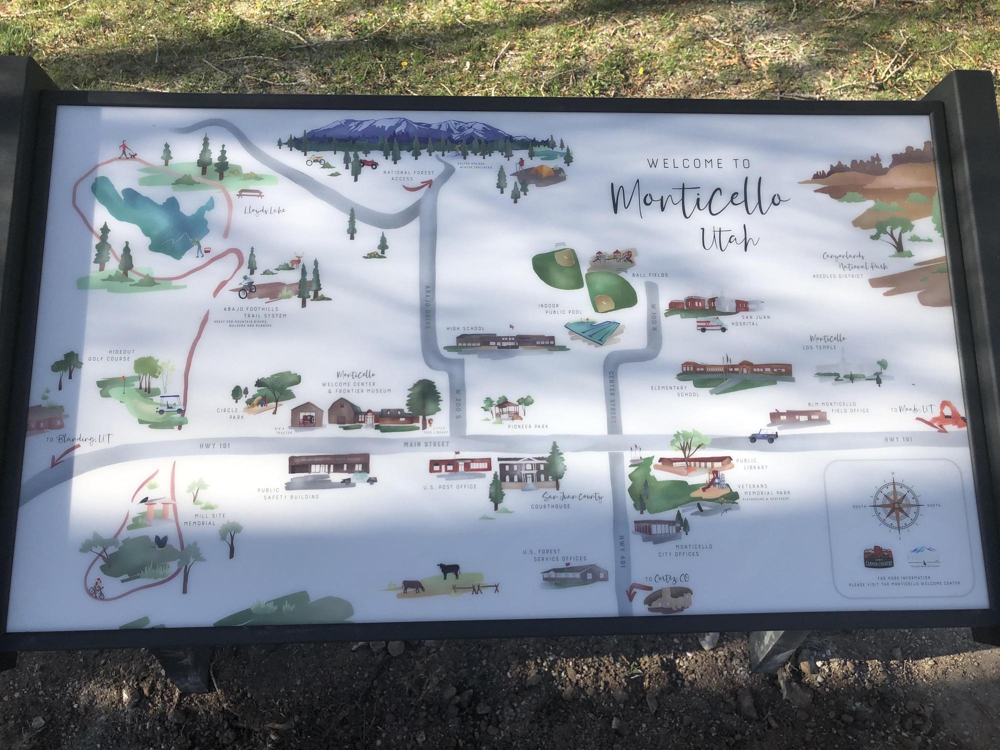
“I’ve spent some time at Veteran’s Park with my kids and have always noticed the volume and variety of people that stop to use the park and its nice wide open spaces.” Hannah says. “ I’ve seen visitors taking a driving break, using the picnic area or exercising their pets, Veterans Park is a popular stop for visitors as well as community members. I’ve always thought to myself that if I was new to the area I’d appreciate looking at a map or sign to see if there were other nice parks or places I could visit in the future.”
Hannah envisioned an artistic informational map just a few steps from the parking area similar to what she had seen when traveling through the national parks. Cassiday Sondregger another member of the Parks and Beautification Committee did research on the makers of such signs. That research led to Pannier Graphics based in Pennsylvania, who offered a large variety of durable, outdoor signs.
“I liked their styles and particularly the wayside design I was envisioning.” Hannah continues. “We chose the low profile traditional design. A graphic artist named Dustin Pullman designed the map of Monticello using our framework for points of interest and artistic style.”
An acquaintance of Carol Van Steeter, the chair of the Parks and Beautification Committee, Pullman's work was a known commodity prior to being engaged to do the job.
“Carol has a connection to his in-laws and was friends with them when they lived in the area.” Hannah reports.
The artist is married to that couples daughter. Pullman, when contacted, said he now feels a need to bring the Mrs back to Monticello for at least a weekend so they can see how his handiwork is displayed. He says the two spent the weekend in Monticello when they were dating and she showed him some of her favorite places. Those memories played into the design.
Funding for the project was secured from the San Juan County Economic Development and Visitors Services office.
“Last year Natalie Randall made us aware of the San Juan County Economic Development and Visitor Services Community Co-Op Grant. The $5000 grant would allow us to make three signs instead of one. We decided that we could put the other signs at the Monticello Welcome Center and at the Lloyds Lake parking area because these would be areas that visitors would most likely need a wayfinding sign for Monticello. The grant money covered the cost of 3 wayside signs, artist fees and installation.” Hannah said.
The San Juan County Economic Development & Visitor Services Co-Op Grant program is administered by the San Juan County Office of Economic Development and Visitor Services. This grant is one of two grants offered by the office, both of which are funded by Transient Room Tax (TRT) dollars with state statute limitations set for tourism marketing efforts. The Co-Op Grant allows flexibility for municipalities, communities, non-profits, and groups of businesses to apply for funding to assist in growing their tourism marketing efforts. Grants can be applied for up to $5,000 per project, with no limit to the number of projects applied for by any one applicant. The applications are reviewed, scored, and voted on by the nine-member Tourism Tax Advisory Board (TTAB)--which is representative of countywide regions and TRT collecting entities. The applications are ranked and a suggested award is presented to the San Juan County Commission who then makes the final approval of the projects.
Randall, director of the Economic Development office was a big help in securing the funding according to Hannah reflecting on the process. “This was the first grant funded project for me. Natalie was encouraging and informative as we went through the process of completing our project for the grant, her office kept us on track with all the grant deadlines.”
And the investment in the map paid dividends aesthetically. Randall made use of the map for Monticello’s new Community Guide Books, soon to be available to all businesses. Bluff and Blanding also have the Community Guide Books for their communities but not with quite the artistic flair the Monticello Parks and Beautification Committee was able to provide.
The stylized tour around town reveals images of the Abajo Foothill Trail System, Lloyd’s Lake, the public library, Hideout Golf Course, the Church of Jesus Christ of the Latter Day Saints Temple, the county courthouse and much more. The next time you’re at Lloyd’s Lake, the Monticello Visitor’s Center or Veteran’s Park, check out the new signs. You might want to set a course for one of the points of interest that is just walking distance away.
For more information on the Co-Op grant and other resources visit: https://www.utahscanyoncountry.com/programs-incentives